
<< episode
Week of April 21, 2024 | View the Map
Right click and SAVE AS
to download the Google Earth file for this episode
Use free Google Earth software
to OPEN it, using File> Open.
Find more tech info here.
Tuesday
This is the final episode of the 2023-2024 Globetracker's Mission: Locating Louie. Teachers will be interested in the review activities available from the Teacher Info link at the right. Remember that you can revisit the entire mission by "rewinding" using the arrows above. This mission will remain online until July 2024, then will be taken offline while Geo and Meri get organized for 2024 - 2025. Stop back to find out more about next year's mission later in the summer.
- The Globetracker's Mission Team at TeachersFirst
This is Pandora. I am sure that you heard ALL about me (good things, of course). I am the younger (and wiser) sister of George Hudson Cartog and Meri Diane Cartog. You know them as simply Geo and Meri. They are both still jet-lagged and tired from their trip home. We are having a surprise "welcome home" party for them on Friday. SSShh - don't tell them!
I have been following their blog for months now, and I have SO many questions!! I mean, think about it - they have been all over the United States chasing this guy Louie, and they finally caught up with him. He hurt himself and lost his memory - wow! And what is going to happen to Louie now? Is he safe? Is he in trouble for running so much?
I also have a TON of questions for Geo and Meri. What was the coolest place they went to? Weren't they scared traveling all over the country alone? Didn't they miss our parents and me? When are they going back to school? Will they pass for the year? Can any kid go on a mission like this? Can I go next time? How much did they get paid? Did they have enough money while they were gone? Did they get sick at all? (Neither one ever mentioned being sick on the blog.) And how in the world did one small suitcase of clothes last both of them for the entire six months and throughout such a variety of climates?
There are still so many details about this mission that confuse me: What was so important about Louie that you had to chase him all over? What is his real name? How did Louie choose all the places he went? Was there something special about his choices? They (and Louie) were in so many dangerous situations. How did they get out of them? Like the time they got stranded on the mountain. Why didn't they just call for help? And what about that hiker they met on that mountain? Who was he? Who were those bad guys that were following Louie? Why were they following him? What is the point of telling us stuff about the size of cities or activities that are important there?
Anyway, I am glad that they are home now. I posted two pictures of my hometown below. So you know where "I" have been for the past six months!! (Well, except for the awesome trip to Hawaii during the holidays.) We have "tourist attractions" in Phoenix, too. I hope I don't get into trouble for logging into their blog. Oh well, it wouldn't be the first time they were mad at me -- hehehe.
- Pandora
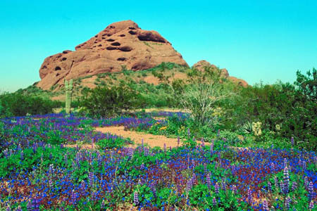
The famous Papago Park in Phoenix! Aren't the spring wildflowers beautiful?
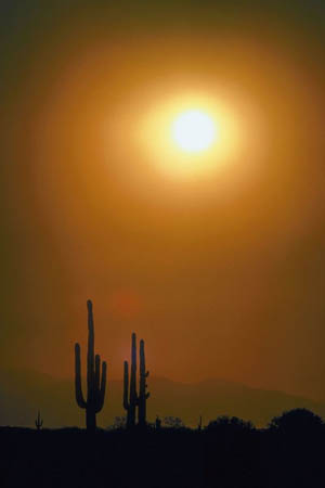
The Sonoran Desert in Phoenix, Arizona.
Map of Arizona (from Pandora)
Here is a map of my home-state of Arizona. What state borders Arizona to the east? What state borders Arizona to the west? How about the northeast and northwest? What country is south of Arizona? Is Phoenix in north, south, or central Arizona?
Tuesday Night
Holy Idaho Pandora!! You do have a lot of questions, not that I am surprised. And thanks for ruining the surprise party for us. Geo took one look at your list of questions, got a headache, and had to go back to bed. So, I will try to answer SOME of them. We don't have the time or space to completely satisfy your curiosity. Here I go:
Why wouldn't the government agency just find Louie themselves instead of sending teenagers on a mission around the United States?
The government didn't want the press (and paparazzi) catching on to the fact that Louie was missing and possibly in trouble, so they thought it would be safer to send us on the mission. The reporters and paparazzi wouldn't think that teenagers would be working for the government.
What is going to happen to Louie now? Is he safe?
Yes, Louie is safe. He did get in a little trouble for running away for seven months, so he lost all of his remaining vacation days for this year. He is back in Washington, D.C. and working with Uncle GT AND the CIA right now. He is busy doing what he does best - making maps.
What was the coolest place you went?
I assume by cool you mean our favorite location, not the air temperature? Geo loved Boston. I enjoyed both Hawaii and Key West. Yes, I enjoy the beach! I wonder what location other kids think was the "coolest" to learn about from our blog. What do you all think?
What was so important about Louie that you had to chase him all over? What is his real name?
Louie Tollemy is a world-famous mapmaker (cartographer). He was working on a special project mapping out the natural resources across the United States - and DISAPPEARED! Although he did send the agency a text message, they still wanted him tracked down and brought back to work. They needed him to finish the project.
How did Louie choose all the places he went? Was there something special about his choices?
The more Louie draws maps, the more he worries about the earth. Louie is very concerned about the environment and wants all of us to pay attention to it. He visited places that had something special environmentally, such as major sources of energy, new ways of generating energy, natural wonders that are being threatened by bad environmental choices, etc. Take the Google Earth tour of all the places Louie visited and try to figure out what environmental worries or wonders are located in each place.
Why do you always tell stuff about the size of cities and the types of things they make or activities that are important there?
The economy of a place is important. It tells us what makes the place "tick," how people earn money, and why the city might have grown in the first place. It also shows the wide variety of locations in the United States! Do you know what supports the economy where you live? Do you think places change? What makes them change?
Weren't you scared traveling all over the country alone?
We weren't alone at all. Geo and I were together. And Uncle GT always knew exactly where we were and met up with us a few times, too. Holy Idaho! We had a great trip. I would go again in a heartbeat!
You (and Louie) were in so many dangerous situations. How did you get out of them? Like the time you got stranded on the mountain. How come you didn't just call for help?
Well honestly Pandora, each situation was a bit different. We were very lucky that our cell phones did have reception in most places. The more dangerous locations and situations, we had Uncle GT with us. And we did end up using a few "gifts" that were given to us from the strangers we met. For example, remember in the beginning of the mission (in Las Vegas), the mom with the MANY kids gave us that state quarter since we helped her watch her kids for a few minutes? Well that quarter is what we used to lure Louie to agree to meet us in Boston! And do you remember the gum wrapper helping us get rescued in the Rockies?
Can any kid go on a mission like this? Can I go next time?
No, every kid can't go on a mission like this. We are very lucky because of having Uncle GT. Otherwise, we would never have gone on the adventures that we already have. We have tagged along with Uncle GT on several other missions (during summers), so he knew we were ready to go on our own. And Pandora, you are WAY too young to tag along. Maybe in 5 years or so you can come too.
How much did you get paid? Did you have enough money while you were gone?
Holy Idaho, Pandora! We didn't get "paid" at all. We got a free trip around the ENTIRE United States. We had plenty of money for food, lodging, and basics because Uncle GT gave us a credit card. The credit card had no limit, but Uncle GT knew that we would be responsible with the money. We were allowed to use the money for tourist attractions, food, transportation, and whatever else we needed. If we had spent the money on other stuff, we would have to pay it back. We were REALLY lucky.
Who was that hiker you met?
The hiker, Mike, was someone we met when we were hiking at Mount Mitchell State Park in North Carolina. Louie quickly recognized Mike as a government agent, although we didn't know that he was! Mike wasn't even looking for Louie; he was just taking a few days off of work to hike in the mountains. But Louie didn't realize that.
Who were those bad guys following Louie?
They weren't "bad guys," they were CIA agents (Rose and Dakota). They were trying to get Louie to agree to come and work to create new maps for the CIA. They obviously didn't want anyone else to know they were CIA agents. So they kept their identities hidden and waited for the right time to approach Louie. They would have just called him, but Louie wasn't answering his cell phone! The CIA wanted only the best cartographer (Louie) to create their maps. So they had to wait until Rose and Dakota could safely catch up to Louie.
Didn't you miss our parents and me?
Not really. It is nice to be back home, though. Plus we got to see you over the holidays in Hawaii. And we even stopped at home for a day a few months ago while we were visiting the Navajo Nation, remember?
When are you going back to school? Will you pass for the year?
In a way we already did go back to school because we came up with a way for teachers and kids to review the entire mission - teachers can find it in the Teacher Info on our blog. Our own teachers are checking it out right now, so it won't be posted for another week or so. We just emailed it to them today. Be sure to check back! Doing this blog (and the review) was our assignment for the months that we missed. Now that we are back, the principal is requiring us to visit every geography and social studies class in the school to do a presentation about our mission. We don't get to pass the year unless we visit EVERY geography and social studies class. We already took the end-of-the-year tests in our other regular classes, before we even left for the mission. So our year will finish successfully.
Did you get sick at all? Neither one of you ever mentioned it in the blog.
To be honest, I did get a few migraines. Geo was fine the entire trip. Thankfully, we stayed healthy. We washed our hands a lot as we traveled!
How in the world did one small suitcase of clothes last both of you for the entire seven months and throughout such a variety of climates?
Well, this wasn't entirely true. We did stop at home for the day a few months ago (remember), and we got some warmer clothes before we headed up north again. The key to traveling around various climates is layering clothing. We did use laundry facilities in hotels a lot!
- Meri
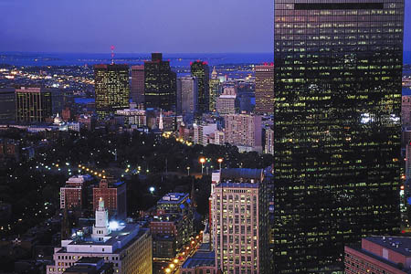
Boston at night - Geo's favorite location!
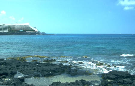
Key West - one of MY favorite destinations. Do you remember my other favorite?
Wednesday
Today Meri and I went back to school. We already had six presentations today about our trip. Today we talked to most of the ninth-grade classes. You know Meri; she is doing most of the talking. But I am the one who is answering the students' questions after the presentation.
I have been thinking about this mission. And I have a few questions that I have been thinking about and want to share with our blog readers. Do you think the natural landforms, resources, and hazards change the way people live, or do people everywhere seem to live mostly in the same way? Why do you think some places get so many more tourists (and picture-takers) than others? And what about global warming - do you think it is going to change the way some people live? How and why?
I wonder how long it will be until our next mission. Which place that we visited would you like to try living for a while? Do you have any other ideas for our next mission? Maybe some of the kids reading this have ideas for another Mission that we can suggest to Uncle GT! Send us your thoughts via Twitter #SFLGlobeTracker.
Well, this is our final blog entry for this Globetracker's Mission. We hope you enjoyed the wild ride. We surely did. We will be back soon on our next mission for Uncle Globetracker (GT for short). Speaking of our next mission, if we get sent on another mission for Uncle GT, where do you hope it will take us? Could it be another US adventure? Or do you think we might get to spend time staying with families and kids in other countries (instead of staying in hotels)? Or do you think that we might get to see natural wonders, not necessarily places with lots of people? What do you think? Maybe you want to write your OWN blog posts about your thoughts and post them in your classroom or on your class web page/blog!
And don't forget to stop back for more reviews of the entire mission in the Teacher Info in a week or so. As a final question for this mission: Vote for YOUR favorite part of Globetracker's Mission: Locating Louie!
- Geo
Vote Here:
116
Copyright © 2011-2024 by The Source for Learning, Inc. All rights reserved.